
Air based WIDE Band Software Defined
JAMMER
Wide band 100MHz – 8 GHz
- Active radio protection by Air,
- Mounted on a drone and acts much more efficiently, since the radiation is from the direction of the GPS satellites.
- Needs much lower RF power.
- Simultaneous software defined channels 5.
- Very long range (LOS)
- Wide band 100MHz – 8 GHz
- Software defined channels. Can set up any channels remotely.
- Several dynamically changing frequencies with different disturbing modulations.
- Rapid suppression. Speed 150 km/hr.
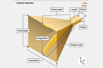
- Lightweight elliptical broadband antenna.
Ground Programming Module : RDK-51 programmer
Programmed Channels | Description | Power | Range |
Ch_1 | GPS, GALILEO, Glonass, BDS, L1 | 35 W |
15+ km |
Ch_2 | GPS, GALILEO, Glonass, BDS, L2 | ||
Ch_3 | GPS, GALILEO, Glonass, BDS, L3 | ||
Ch_4 | 420 ÷ 490 MHz | ||
Ch_5 | 720-840 MHz | ||
Ch_6 | 980-1100 MHz | ||
Ch_7 | 2200-2485 MHz | ||
Ch_7 | 4,9- 5,8 GHz | ||
Power supply – 12V | |||
Weight : RF block 7,5kg , antennas 2,5kg | |||
Humidity 30÷ 90% | 3temperature -30÷ +65 ℃ | ||
Време за програмиране : < 5мин , опция In_Air_prog @ бел 1 | |||
Модул за наземно програмиране : RDK-51 programmer | |||
Bell 1 : A programming option is possible In_Air_prog the disturbing carriers during flying. This shortens the preparation time before takeoff.
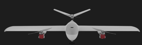
Next generation tilt rotor VTOL.
Wingspan 2m
Max range 140km
Max flight time 2 hours / 6 hr gasoline
Max payload 1,5/2 kg
Max takeoff weight 8kg
Max flight altitude 55000m
Command & Control range 60km+ with antenna tracker
Cruise speed 80 km/hr
Wind tolerance Hoover 14 m/sec
Wind tolerance gusting cruise 24 m/sec
Transport Case Dimensions 220 x 83 x 27 cm
IP 55
Air based WIDE Band Software Defined
JAMMER
Wide band 100MHz – 8 GHz
- Active radio protection by Air,
- Mounted on a drone and acts much more efficiently, since the radiation is from the direction of the GPS satellites.
- Needs much lower RF power.
- Simultaneous software defined channels 5.
- Very long range (LOS)
- Wide band 100MHz – 8 GHz
- Software defined channels. Can set up any channels remotely.
- Several dynamically changing frequencies with different disturbing modulations.
- Rapid suppression. Speed 150 km/hr.
- Lightweight elliptical broadband antenna.
Ground Programming Module : RDK-51 programmer
Programmed Channels | Description | Power | Range |
Ch_1 | GPS, GALILEO, Glonass, BDS, L1 | 35 W |
15+ km |
Ch_2 | GPS, GALILEO, Glonass, BDS, L2 | ||
Ch_3 | GPS, GALILEO, Glonass, BDS, L3 | ||
Ch_4 | 420 ÷ 490 MHz | ||
Ch_5 | 720-840 MHz | ||
Ch_6 | 980-1100 MHz | ||
Ch_7 | 2200-2485 MHz | ||
Ch_7 | 4,9- 5,8 GHz | ||
Power supply – 12V | |||
Weight : RF block 7,5kg , antennas 2,5kg | |||
Humidity 30÷ 90% | 3temperature -30÷ +65 ℃ | ||
Време за програмиране : < 5мин , опция In_Air_prog @ бел 1 | |||
Модул за наземно програмиране : RDK-51 programmer | |||
Bell 1 : A programming option is possible In_Air_prog the disturbing carriers during flying. This shortens the preparation time before takeoff.
Next generation tilt rotor VTOL.
Wingspan 2m
Max range 140km
Max flight time 2 hours / 6 hr gasoline
Max payload 1,5/2 kg
Max takeoff weight 8kg
Max flight altitude 55000m
Command & Control range 60km+ with antenna tracker
Cruise speed 80 km/hr
Wind tolerance Hoover 14 m/sec
Wind tolerance gusting cruise 24 m/sec
Transport Case Dimensions 220 x 83 x 27 cm
IP 55
Budget 4 channels x 30 W each
Portable electronic countermeasure system against UAV
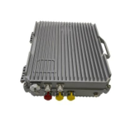
Operating frequency ranges:
- 410-450 MHz;
- 729-1100 MHz;
- 1150 MHz – 1250 MHz L2/L5
- 1420-1440 MHz;
- 1500 MHz L1
- 2400-2500 MHz;
- 4900-5250 MHz;
- 5600-5850 MHz;
Operating temperature: from -30 C to +45 C.
Power Source: Battery/Replaceable Battery.
Continuous operation time: at least 40 minutes.
Protection grade: IP67.
Protection against overload and overheating.
Battery life of at least 30 minutes
In the case of installation on a vehicle: Installation kit /
A solution proven on the move and off-road.
Priority equipment with antenna device/power supply and the ability to quickly replace the antenna.
Power Supply: DC-24-28V/2A | |
Weight: Main unit –3 kg ; Antenna 600-6000MHz – 0.54kg | |
Humidity: 30 ÷ 95% Operating temperature: -20 ÷ +65°C | |
Antenna Type | Omnidirectional |
The set contains | |
Main Unit Al Case – 1pc | |
Antenna – 1pc | |
Antenna cable – 1pc | |
Power cable – 1pc | |
AI Optical tracker of Ground targets
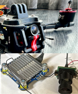
Machine learning vision NEURAL PROCESSING UNIT (NPU)
Runs at up to 2 GHz with an integrated neural processing unit (NPU) that delivers up to 2.3 TOPS.
- Requires Operator confirmation for target lock
- Max tracking distance: 300m for 5x5m objects
- HD Low light digital optical camera 0,002 lux
- Autonomous tracking for moving targets
- Autonomous guiding system for Betaflight.
- AI OSD integrated
- Malvlink guidance protocol
- Integrated with Betalight and Ardupilot
- Copter and Fixed wing version
- The AI seeker is fully Resistant to Electronic countermeasure, IR jamming and laser jamming
- Integrated with the remote control.
Detects and tracks targets in through weather;
HD low light camera provides enhanced target discrimination.
FEATURES
- Multicore processing and memory interfaces
o 4x 1.8GHz
o up to 800MHz
o 32/16-bit DDR4 and LPDDR4 up to 4.0GT/s
- Machine learning and vision
o Neural Processing Unit (NPU) delivers up to 2.3 TOPS
o Dual Image Signal Processor (ISPs) resolution of up to 12MP and input rate of up to 375MPixels/s
o Camera interface 2x MIPI CSI
o Video encode 1080p60, h.265/4
o GPU 16 GFLOPS (high-precision) OpenGL® ES 3.1/3.0, Vulkan®, Open CL™ 1.2 FP
o Display MIPI-DSI, HDMI 2.0a Tx, LVDS (4/8-lane) Tx
Tracked object types | Vehicle |
Computing power | 2.3 TOPS |
Power consumption | 8 WT |
Power input | 12,6-25,2 3S 6S |
Video Steam Codec | H 264 H265 |
Dynamic Target Collaboration | Locking target Auto guiding mode to target |
Locking target accuracy | 92% |
Types of vehicles | Copters and fixed wing |
Working temperature | -10 +50 |
Dimensions | 43,4×45,1×26,5 |
Weight | 60g |
Long Range 2×2 MIMO Wide Band RC & Telemetry
FHSS 330 MHz – 1050 MHz, 2900 mW
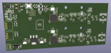
Range 80 + Kilometres.
Full Duplex Telemetry
Built in serial Radio Modem.
MAVLINK SUPPORT
2900 mW (2 x 1450 mW) high Power Telemetry.
Full 80+ Kilometer RC Range and 80+ Kilometer Telemetry Range.
Long range radio modem capability – no need of second radio link.
SPECIFICATIONS
Wide Band
- Radio Type MIMO Coded-OFDM
Frequency Hopping SPREAD SPECTRUM (Custom mode optional)
- UHF 330-520 * C-1 Band
- ISM 720-1050 * C-2 Band
Typical Range: 80+ km Using Supplied multiband Antennas
- Encryption DES Standard AES 256/AES 128
- DATA compression YES
- DATA BURST MODE YES
- Subcarrier Modulation BPSK, QPSK, 16-QAM, 64-QAM
- Channel Bandwidth 5, 10 & 20 MHz
- Frequency Stability 1 PPM over temp -40° – +85° C
- Tuning Step Size 1 KHz
- Data Rates 9 600 bps / 19 400 bps
- Error Correction 1/2, 2/3, 3/4, 5/6
- Antenna Processing Spatial Multiplexing, Space-Time Coding, RX Eigen
- No. of Antennas 2 multiband Antennas
- Transmitter Power Output 100 mW – 2,9 W (2 x 1,45W)
- Remote Control supported protocols CRSF , PWM, ACCESS
Performance
- Latency 5-12 ms (average 6ms)
- Sensitivity Varies with MCS index
Maximum 102 dBm (5MHz BW, MCS 0)
- Power Consumption 4.8 W – 24 W
Transmitter / Receiver Module Voltage: 5 – 18 Volts (2-4 cell LiPo)
Programmable Transmitter or Receiver MODE
LED for status monitoring.
Audible alarms (Low Voltage, Low RSSI )
- RF TNC (2 Each)
1x RS232, DC Input (Optional)
- 2 x Auxiliary Ruggedized Circular Connector
- Status Indicator Bi-Color LED
- RF Connectors 2 pcs SMP (m)
Weight: 90 Grams
Length: 79 Millimeters
Width: 70 Millimeters
Thickness: 17 Millimeters
Ambient Temp. -40° to +65° C
Optional – WiFi module for display of telemetry on Smartphone.
INCLUDED
1 Long Range Transmitter/Receiver
2 pcs Multiband Antennas
2 pcs Connection Cable
AUTHONOMOUS GPS Jammer SEEKER
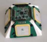
Frequency range | GPS L1, L2. L5 |
Antenna diagram | 220° sector |
Guidance | Seeks GNSS Jammer L1, L2. L5 |
AI system | Seek area based on GPS fencing Identifies closest jammer/Spoofing systems |
ALL WEATHER: | Rain, Fog, Hurricane, Heavy snow |
Accuracy | ± 2 ° |
Max range | 30 km LOS |
Digital interface | RS232, UART x2 |
Servo control | PWM x 2 |
interface | a) RS 232 b) MAVLink (optional) c) Own Fixed wing Autopilot with 2 PWM. (optional) |
Compatible autopilots | ArduPilot / PixHawk |
Processor | STM32 |
Dimensions | Diameter 90mm x 60mm |
Total Weight | 135 g |
Power source | 4V – 24V |
Consumption | 50 mA |
Shelf Life | 10 years under storage conditions |
Minimum Temperature for use | -52° C |
Maximum Temperature for use | +90° C |
Minimum Temperature for storage | -55° C |
Maximum Temperature for storage | +105°C |
Drone Jammer Gun 8 channel x 40 W each
Complementary to 3D UAV Radar
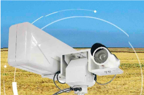
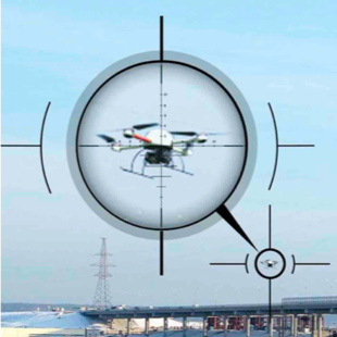
Automatic aiming of the electronic jamming device at the UAV
Automatic aiming of the thermal-imaging camera (video camera)
UAV deactivation
Operating frequency ranges:
- 410-450 MHz; Optional
- 729-900 Mhz
- 900 -1100 MHz;
- 1150 – 1250 MHz L2/L5 Optional
- 1500 MHz L1
- 2400-2500 MHz;
- 4900-5250 MHz; Optional
- 5600-5850 MHz;
For city operation can select required channels and emitting power (5W or 40W/channel)
- Range: 3km/15km
- Cold start: < 0.1s
- Operating time: > 1h
- Directionality: 30°
- Weight: 9,5kg
- Configuration software
- Operating temperature: from -30 C to +45 C.
- Continuous operation time: at least 40 minutes.
- Protection grade: IP67.
- Protection against overload and overheating.
- A solution proven on the move and off-road.
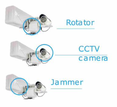
The set contains:
- Main Unit – 1pc
- Power cable – 1pc
- EO/RI camera- Optional
- PTZ platform – Optional
Imitator of Targeting radars and
Counter Artillery Radars
- AN/TPQ-36
- AN/TPQ-37
- AN/TPQ-50
- AN/TPQ-53
- Patriot
Software Defined Imitator of RLS
Pulse power 2,5kW or 20 KW
Antenna – horn-reflective;
Directional action diagram – about 70º in azimuth and 30º in elevation angle;
Carrier frequency 9,4 GHz or customer defined
Response period – programmable
Pulse duration – programmable
Range: 200 km for 2,5kW and 600 km for 20kW
Control – remote , programmable
Option 2,5kW:
Option 20kW:
Budget Imitator of RLS
Pulse power 2,5kW or 20 KW
Antenna – horn-reflective;
Directional action diagram – about 70º in azimuth and 30º in elevation angle;
Carrier frequency 9,4 GHz
Response period – Fixed
Pulse duration – Fixed
Range: 200 km for 2,5kW and 600 km for 20kW
Control – remote, programmable
Option: 2,5kW
Option 20kW
Budget GPS-Aided Iner�al Naviga�on System
INS + AHRS + Air Data
L1/L2
Inertial Navigation System , Attitude & Heading Reference System (AHRS) + Air Data
determines position, velocity and absolute orientation (Heading, Pitch and Roll)
Fixed Wing UAV, Copter, Land Vehicle Navigation Flight Control and Navigation in longterm GNSS-Denied
Product Code Description:
- GPS-Aided Inertial Navigation System
- Position accuracy = 1 cm (RTK)
- Update rate 200 Hz
- Heading accuracy = 0.3 deg (RTK, Dynamic)
- Pitch & Roll accuracy = 0.08 deg (RTK, Dynamic)
- Gyro-compensated, embedded Fluxgate magnetic compass
- ·Gyroscopes measurement range = ±2000 deg/sec
- ·Accelerometers measurement range ±15 g
- Airspeed Pressure Port (Total/Static)
- Barometer
- Triple-Frequency, Multi-Constellation, RTK Capable GNSS Receiver
- GPS L1/L2/L5, GLONASS L1/L2/L5, BEIDOU B1/B2, GALILEO E1/E5, QZSS L1/L5, DGPS, RTK, 20 Hz measurements, 20 Hz posi�ons
- RS-232 interface (INS data)
- UART interface
- I2C interface
- External Lidar 200m ( optional)
Units | ||
Update rate | 1… 200 (user settable) | Hz |
Start-up time | <1 | sec |
Positions, Velocity, and Timestamps | Units | |
Horizontal position accuracy (SP), CEP | 1.5 CEP | meters |
Horizontal position accuracy (RTK), CEP 0) | 0.01 + 1 ppm CEP | meters |
Vertical position accuracy (RTK) 0), CEP | 0.01 + 1 ppm CEP | meters |
Velocity accuracy, CEP | 0.05 | meters/sec |
Heading | Units | |
Ranqe | 0 to 360 | deq |
Angular Resolution | 0.01 | deg |
Static Accuracy (2) | 0.6 | deq RMS, la |
Dynamic accuracy (GNSS) (3) | 0.3 | deg RMS, la |
Pitch and Roll | Units | |
Range: Pitch, Roll | ±90, ±180 | deg |
Anqular Resolution | 0.01 | deq |
Static Accuracy in Temperature Ranqe | 0.08 | deg, la |
Dynamic Accuracy(3) | 0.05 | deg RMS, la |
GNSS receiver | Units | |
Type | GNSS Antenna | |
Supported GNSS signals & corrections | GPS L1C/A L2C, L5, GLO LlOF L20F, GAL E1B/C E5b, BDS B1I B2I, QZSS L1C/A L2C L5 SBAS L1C/A: WAAS, EGNOS, MSAS, GAGAN, NAVIC L5 | |
Channel configuration | 184 Channels | |
Raw GNSS data rate | 10, 20 | Hz |
Accuracy of Time Pulse Siqnal | 30 (RMS), 60 (99%) | Ns |
Frequency of Time Pulse Siqnal | 0.25 – 10,000 (configurable) | Hz |
GNSS Convergence time(4) | < 10 (GPS±GLO/GAL/BDS); < 30 (GPS) | Sec |
Acquisition time (5) | <30 (cold start), <2 (warm start), <1 (hot start) | Sec |
Input signals | External LIDAR sensor | |
Electrical | Units | |
Supply voltaqe | 5-32 | V DC |
Power consumption | <2 | Watts |
Output Interface | UART or RS-232 | – |
Output data format | Binary, NMEA 0183 ASCII characters | – |
1 PPS Level | 5 | V DC |
Environment | Units | |
Operating Altitude | Ud to 9000 meters | meters |
Humidity | <94 | % |
Operating temperature | -40 to +85 | deg C |
Storage temperature | -50 to +90 | deq C |
Type of Sealinq | IP-67 | |
Sand, Dust, Water, Humidity, Shock, Vibration | MIL-STD-810G | |
MTBF (GM) | 50,000 | hours |
Physical | Units | |
Nominal Size (7) | 80.0 x 50 x 30 | mm |
Weight(7) | < 180 | gram |
Targeting RADAR SEEKER
Frequency range | Seeks Observation 3D radars
Seeks Targeting radars
|
Antenna diagram | 220° sector |
Seeks | Panzir, Thor, BUK, S300/500, Patriot, Iris, Iron Dome |
AI system | Seek area based on GPS fencing Identifies closest radar |
ALL WEATHER: | Rain, Fog, Hurricane, Heavy snow |
Accuracy | ± 2 ° |
Max range | 100 km LOS |
Digital interface | RS232, UART x2 |
Servo control | PWM x 2 |
interface | a) RS 232 b) MSP c) Own Fixed wing Autopilot with 2 PWM. (optional) |
Compatible autopilots | ArduPilot/ Betaflight |
Processor | STM32 |
Dimensions | Diameter 90mm x 60mm |
Total Weight | 185 g |
Power source | 4V – 24V |
Consumption | 50 mA |
Shelf Life | 10 years under storage conditions |
Minimum Temperature for use | -52° C |
Maximum Temperature for use | +90° C |
Minimum Temperature for storage | -55° C |
Maximum Temperature for storage | +105°C |